.
|
Expeditions
and Searches - 1937 to Present-Day
Search 3 - November
1938 (continued): |
.
.
Search
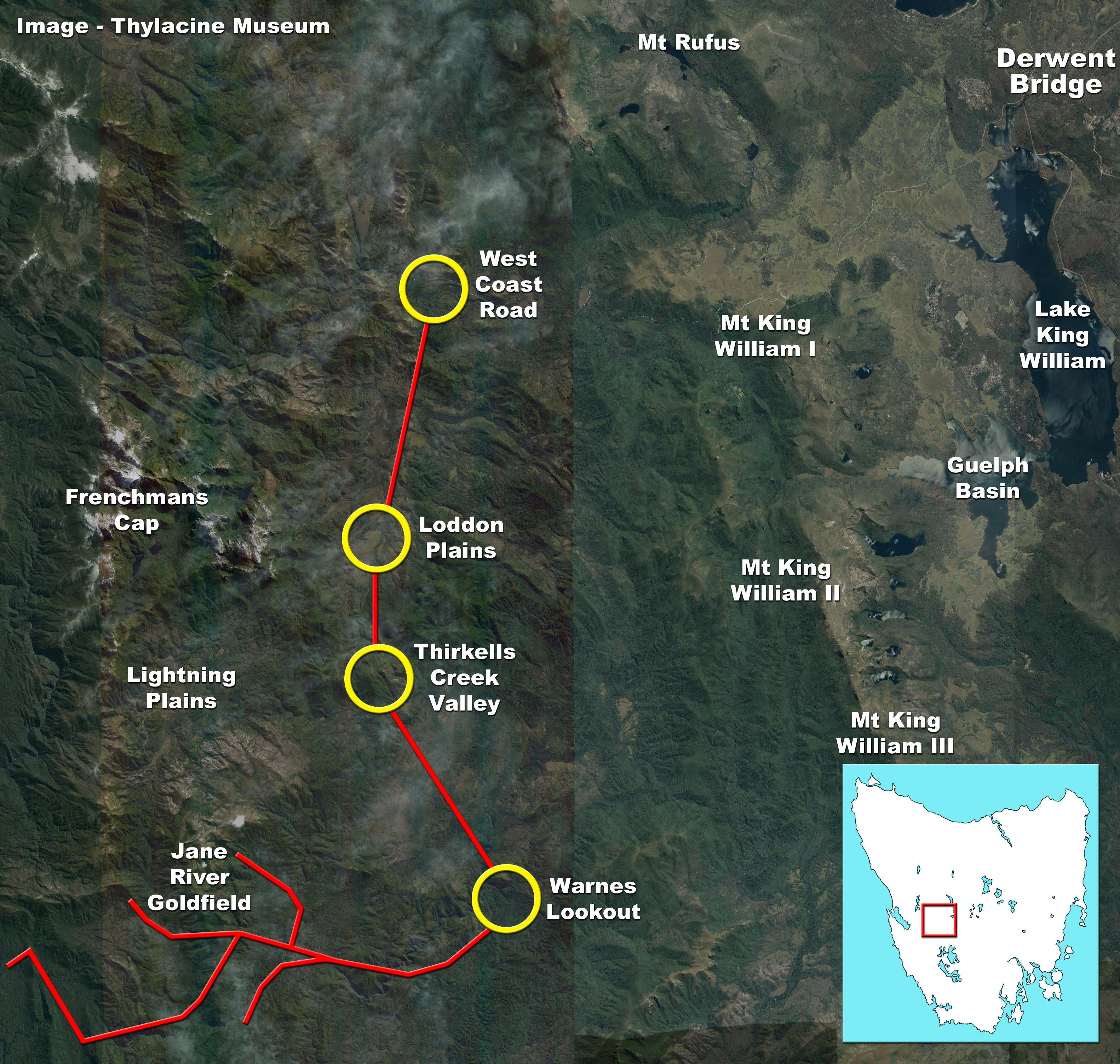
Area 3 (Jane River & Frenchman's Cap).
Satellite
image: Google Earth. Place your pointer over the map to magnify.
|
.
| We then continued
to the Jane River Goldfield, where we made our headquarters, and from there
explored the surrounding country - west and south-west of Jane River Goldfield,
and along a muddy tributary of the Jane River, south-west of Warnes Lookout.
We found tracks of the thylacine that were defined clearly enough to obtain
a plaster cast, and travelling from the Goldfields on the 18th to the upper
reaches of the Jane River, we traced the thylacine in several places, along
the banks of the river also onto Lightning Plain, near what is known as
Riner's Camp. Here we camped for two days, exploring the country
around. We obtained further evidence that thylacine still inhabited
this locality and we secured our last plaster cast of the footprint of
one of these animals. Although we discovered tiger tracks on the
Loddon Plains, they were not sufficiently defined to enable casts to be
taken.
On the morning of
the 21st instant we continued on the track leading to the West Coast Road
which we reached during the afternoon. We proceeded to Derwent Bridge
where we stayed for the night. On the 22nd instant we joined a motor
conveyance and travelled to Hobart.
The country which
we traversed during our search consists chiefly of thickly timbered hills
with patches of Button Grass between. The undergrowth and foliage
on the Jane River field is particularly dense. The country between
Frenchman's Cap and the Jane River field being higher and consequently
very much drier than the lower country over which we had travelled between
Prince of Wales Range and Flag Staff Hill, forces me to the conclusion
that the first mentioned area would be suitable country upon which tigers
could live. |
.
.
|
Approximate boundary
of thylacine sanctuary as proposed by Fleming. Satellite image: Google
Earth.
|
.
| I am of the opinion
that the area I refer to would make a suitable sanctuary for the Tasmanian
tiger if sufficient country be included to enclose Frenchman's Cap and
Raglan Range on the western side, and the Prince of Wales and King William
Ranges on the eastern side - extending northerly as far as the West Coast
Road. My reason for including such a large area is that the mountainous
country would be necessary for breeding and resting grounds, and would
be places where the tigers would not be disturbed by any person, while
the lower lying grounds would supply the game necessary as the food for
the tiger. The area I refer to for that of a sanctuary would enclose
about 30 miles".
The Mercury newspaper
of the 23rd November 1938 (p. 6), records the return of the expedition
to Hobart: |
.
| "The expedition
which visited the Jane River district on the West Coast in search of the
Tasmanian tiger, returned to Hobart yesterday. Although the party
did not see any tigers, it proved that the district examined was inhabited
by these animals, and it is likely the Government will be recommended to
proclaim as a faunal sanctuary an area extending from the West Coast Rd.
at Mt. Arrowsmith to south of the Jane River gold prospecting field.
The footprints of tigers were found in several places in muddy patches
on the button grass plains, and the impressions were so well defined in
most cases as to enable perfect plaster casts to be made from them.
In one case, when the party was camped in a pine cutter's camp on the Jane
River, it was proved by footprints that a tiger had come round the camp
during the night. Mr. M. S. R. Sharland, a member of the council
of the Royal Zoological Society of New South Wales, who accompanied the
expedition as a guest of the Animals and Birds Protection Board, said yesterday,
when interviewed, that one reason the tiger |
| was not seen
was that it was mostly nocturnal in habits, and retired by day to the seclusion
of caves and rock cavities in the broken hills, where it was almost impossible
for any person to penetrate. At night it came down to the plains,
following in the tracks of wombats, wallabies and other game. Footprints
indicated that while game was not so common in the area as in the central
highlands, and on parts of the East Coast there was still ample food for
any tigers that inhabited that part of the State. Tracks of devils,
native cats, wallabies, brush opossum, and some domestic cats gone wild,
were revealed by an examination of game trails across the moist plains.
The area visited by the party, Mr. Sharland said, comprised a series of
deep plain-like basins enclosed within a vast amphitheatre, with encircling
mountains rising to nearly 6,000ft. Leaving the West Coast Rd. at
a point between the Surprise Valley and Frenchman's Cap, about 120 miles
from Hobart, the party crossed the Franklin Range and descended into the
first of these basins, which consisted mostly of wet buttongrass plain.
Then traversing a second basin, partly along the route taken by Sir John
Franklin, Governor of Tasmania, on an overland trip to Macquarie Harbour
nearly 100 years ago, the party reached the Jane River gold prospecting |
.
|
The Courier-Mail, 23rd
November 1938 (p. 6).
|
|
|
| field, approximately 23 miles from
the road, and here established its field quarters. From this point
survey trips were made to adjacent mountains and river valleys. The
amphitheatre in which the tiger is known to live, Mr. Sharland said, was
about 30 miles wide and about the same distance north and south.
It was bounded on the east by the King William Range, and the Prince of
Wales Range, on the south by the Jane River hills, on the west by the Surveyor
and Deception Ranges, and on the North by the Junction Range and Mt. Arrowsmith,
and in the north-western corner, stood the enormous bulk of Frenchman's
Cap with broken peaks and crags rising to about 5,000ft., and composed
of marble-like conglomerate rock which, from a distance, resembled snow.
Within this area were well-wooded hills, extensive boggy plains, several
streams, and dense beech forests. Mr. Sharland warmly praised the
bushcraft of Trooper Arthur Fleming who led the party, and said that Trooper
Boyd and Constable Royle were efficient assistants. The party also
had a highly competent guide in Mr. A. J. Best, whose knowledge of that
part of Tasmania probably could not be equalled".
Michael Sharland, writing
in 1941, states:
"Evidence found during
the trip pointed to the existence of the animal in several parts of the
territory, proving that there was yet time to afford it the protection
so long overdue. We were content to have found definite evidence
of the thylacine's existence".
.
Thylacine track casts
taken during the 1938 expedition. Image: Col Bailey.
Courtesy: Tasmanian Museum
& Art Gallery thylacine exhibition (specimens A3916a/b).
|
|
|
. |

")

")